I have now owned my Quax36 for a month now and after being inspired by Cathy’s excellent 30 mile effort I decided it was about time to up the mileage. My previous rides (5 in total) had been 8, 10, 6, 7, and 11 miles. I’m been really pleased with my progress on the 36er so far as mounting was done 1st time I tried and every time since. I put this down to a lot of 29er riding recently and infact riding the 36er doesn’t feel that different to my 29er, it’s not as nimble but I can still weave in and out. Some people have asked about the wheel being heavy with 48 spokes but I don’t notice it, then again I don’t have another coker to compare it to.
I decided on attempting to ride to Pakenham Water Mill which was about 20 miles away and meant I could use a lot of cycle routes avoiding busy roads. After a bit of faffing I set off at 10.20am, and after a few mins soon reached the cycle route which took my past a local primary school. There were a few barriers to navigate and some lights but after 22 mins of riding I had more of a run. Soon I was on the Sustrans route 51 and leaving the town behind, now passing alongside fields and countrysides rather than housing estates. Along the way I meet a retired couple cycling who had lots of questions about the big wheel and I stopped with them so they could get a photo.
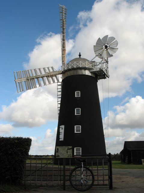
After about an hour I passed though the village of Pakenham and soon the tall restored Windmill loomed over the trees. A quick photo stop and leg stretch later I was back riding the short distance to the watermill. Arriving at my destination looking forward to a bite to eat and a loo stop I was disappointed to find out that it was ‘closed’! I decided to have a look around anyway and eat the bag of crisps I had packed. I had ridden about 10 miles so far in about 1 hour 15 mins. I needed the loo and was very hungry - what I great incentive to ride faster on the return leg!
My right knee had been playing up for the last mile so I upped the seat post by 15mm and noticed the difference immediately - much better and no knee pain. The return journey seemed to go quicker but I suspect it was just because I knew where I was going this time round and didn’t have to keep checking the gps. Some friendly guy on a bike rode with me part of the way back and rode on ahead to keep a look out for cars when I was crossing the roads.
Soon I was back home and eating lots of food. All in all a very nice ride, lovely scenery, nice friendly people, and a new personal best. My legs felt like they had done some work but I wasn’t too saddle sore. Going to be a while before I add another 10 miles to that total however.
Gps Stats
21.4 miles
9.8 mph moving average for 20.25 miles
4.8 mph moving average for 0.82 miles
0.9 mph moving average for 0.37 miles
Stopped for 20 mins
Total time 2 hours 38 mins
Hmph, show off I’m still not very good with the mounting, it’s just too damn high!
Sounds like a great ride. I like the way you linked to the cycle route. Very slick, I’ll have to remember that next time.
Bugger about the cafe being shut. I remember walking up Snowdon once, only to find the cafe was shut. Not a pleasant experience.
And yes, one of my biggest grips about my ride was there was no toilet stop. Infact, I’m wondering how I’m going to up my mileage significantly. Four hours with lots of water drinking and no public loo was just about long enough.
What a lovely destination! Sure wish we had historic wind and water mills (not to mention castles, etc.) to plan into our routes here in the metropolitan area of Minnesota, USA:o
Happy riding!
Actually though, for N.A., Minneapolis is an historic milling town on the Mississippi River. I pass by this on my Coker quite often - a ‘restored/stabilized’ ruin.
For me personally I would never go back to a cyclometer. I love being able to plan routes and put them in the GPS and also downloading routes that I have ridden etc. What I like about the GPS is that you get recorded stats for ever part of the journey.
Have a look at sporttracks. It’s free software I use to keep account of my rides.
Great write up there Norry. Looks like you had a good day out. At least in the photo it looks like the route was well sign posted. Some routes tend to miss an important sign here or there, which leaves you heading in totally the wrong direction.
Well, it looks like Genbirch has beaten me to it by asking about your GPS. I bought a Garmin Vista at the weekend, and was then surprised that it doesn’t come with ANY software at all, and the MapSource stuff they recommend costs a fortune. I’ll check out SportTracks though, as that looks like just what I’m looking for.
Congrats! (I must’ve missed previous thread) And welcome to the club!
I own the new qu-ax 36" as well
The same here…
Pfff haha I’m with you Cathy. I’ve been riding The Big One for 2-3 months now and still I freemount only once in 3-4 times.
You do have T7, don’t you?
Do you mount single-handedly or do you hold T7 with both hands while freemounting?
Yes, I do also have a smartphone + bluetooth gps, but it’s not Nokia. It is great for TomTom, which is excellent as an on-the-move navigational aid for driving or cycling along roads, however, it doesn’t allow pre-plotting of routes, or off road stuff. The logging software I have will record where I’ve been, but it does limit what I can do with the phone whilst it’s running.
That’s why I went for a dedicated handheld GPS doo dah.
I’ve been using the maps stuff on an N95 (that I won as a prize), and it really is rather nice, and having the proper OS maps on screen is really very nice, and it’s a much nicer screen than most GPS devices. The only downside is that I’m more paranoid about it than I would be about a standalone device, what with it being worth quite a lot of money. It’s nice having the GPS always with me, for timing my commute.
Memory maps is available for windows mobile which is similar to viewranger, but again it’s expensive…
I too am new to the 36 community and mounting is the most difficult part. I have a t7 and I have found i do best to hold the T7 with both hands and immediately let go when I start up. It allows may arms to be free for balance (and stop my fall! Ha!). As for the 21 miles… did you really go28 mph or was I reading that wrong?
Way to go! Great job.
Your reading it right! but sadly my max speed wasn’t 28 mph. More likely the gps lost reception for a moment and when it gained reception I would have moved so it gained that distance as a speed increase. The software I use to download the information ignores those blips and gives a top speed of 13.1 mph.