Sounds great! I can make it for Friday and all day Saturday. I’ll bring the veggie burgers!
Im going to be at the beach form the 18-24 so I wont be able to make it. 
Im going to try and organize a ride a Snowshoe this summer though so keep an eye out.
I’m sorry, I only eat unicycles when they have been cooked by expert unicycle cooks. ![]() Oh, you mean we’ll be able to eat while we unicycle, but we’ll have to go slowly because the cook isn’t very fast (it must be hard to carry a stove on a MUni) - that’s OK, I don’t like fast food anyway.
Oh, you mean we’ll be able to eat while we unicycle, but we’ll have to go slowly because the cook isn’t very fast (it must be hard to carry a stove on a MUni) - that’s OK, I don’t like fast food anyway. ![]()
I’m planning my (extended) trip to include WCVMRI and NAUCC 2006, after all it’ll be only a few days later. However, I like to plan way ahead, what are the directions and/or an address (my mapping software can work with most addresses)?
Once again I extend an invite to any one wanting to ride with me, I’m planning on leaving central CT Friday early in the AM, my expected route remains the same (see earlier post.) However, be advised that I intend to stop for a day in Corning, NY on the way home from NAUCC.
By the way, is West Central Virginia similar to the University of Southern North
Dakota at Hoople? ![]() Yes, I’ll be listening to that stuff, too.
Yes, I’ll be listening to that stuff, too.
I’ll try to keep the 24th open for this.
The address is 449 Lookout Mountain Lane Mount Solon VA 22843
The closest street that may be on your mapping software would be Stribling Springs Road (Route 730). Lookout Mountain Lane is 1 mile from the intersection of 730 and 747(Freemason Run). I’ll get some good directions up soon.
Know, I meant I know a beginner unicyclist who can also cook, and I was suggesting we eat her.
I mentioned this ride to her, and explained that she should join us for the easy stuff like distance riding, and while we’re out mountain unicycling, she should stay home and cook and later do all the dishes. For some reason, she seemed a little upset. She didn’t give a definate answer, but she did ask if she’d be the only female. ![]()
Nope, got it in one, 449 Lookout Mountain Lane, ZIP 22843 was all it needed. ![]()
![]()
![]()
Will these do: ![]()
from I-81, take Exit 240 SR 257 (Friedens Church Rd)
In 0.24 mi Turn right (NW) on to SR 257 (Friedens Church Rd)
in 0.63 mi Turn right (N) on to US 11 (N Main St)
in 0.23 mi Turn left (WNW) on to SR 257 (Dinkel Ave)
in 2.53 mi Turn left (WSW) on to SR 42 (Warm Springs Pike)
in 3.60 mi Keep right (W) on to SR 747 (Mussoq Creek Rd)
in 0.96 mi Turn left (SW) on to SR 613 (Mossy Creek Rd)
in 0.36 mi Keep right (WSW) on to SR 747 (Mossy Creek Rd)
in 5.47 mi Turn left (SW) on to SR 730 (Stribling Springs Rd)
in 0.48 mi Turn right (W) on to Lookout Mountain Ln
in 0.33 mi Stop at 449 Lookout Mountain Ln
Note the airport (upper left) for fly-ins.![]()
![]() All the other little roads are listed as service roads.
All the other little roads are listed as service roads.
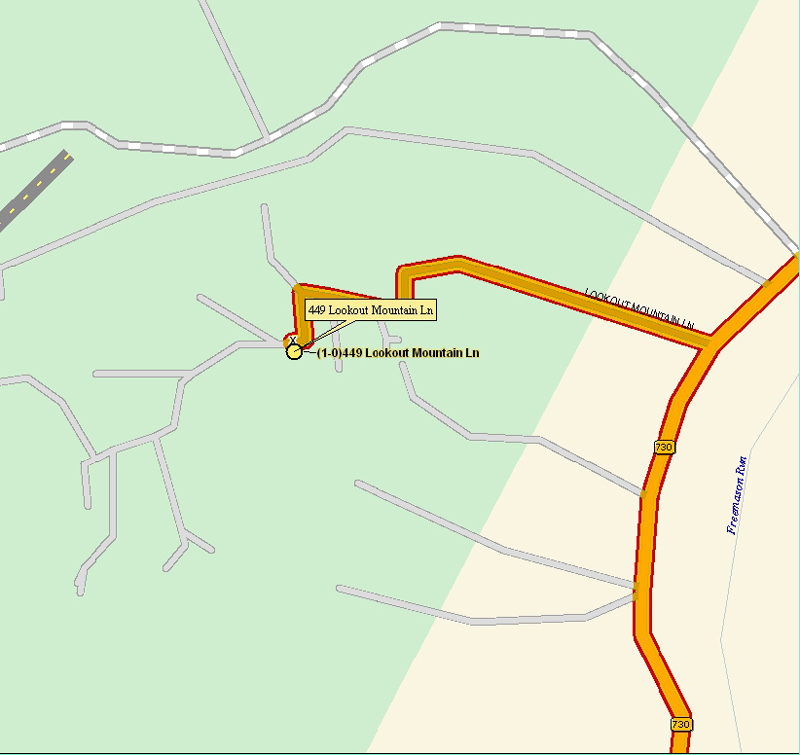
The outcome is right, but the in between 81 and my house is a little squirrely. I’ll get some better directions up.
The 24th is a go. I did 2 shorter rides down the mountain this weekend. It was a blast. Mostly I’ve been road riding on my Coker. Coker riding definitely uses different muscles.
I’ll tell some of my unicycling friends about it. Its likely that they won’t go, but its worth a chance.
Well it’s just 2 weeks away. I will get accurate driving directions up by monday.
ok cool. If the weather is good my dad and I will come, he will probably stay in a hotel and do some bike riding. We will either come up Friday afternoon or around noon on Saturday.
No need for him to stay at a hotel unless he wants to.
Here are detailed instructions to my house from I 81. If anyone need any other help getting here let me know.
Coming From North on I 81:
I 81 south past Harrisonburg to exit 240 (Mount Crawford). Go right onto 257 (west) for approximately 3 miles to the end. Take left onto Route 42 (south). Follow Route 42 for 10.9 miles; turn right onto Route 760 (Bunker Hill Road). Go 3.4 miles to end. Turn left onto Route 747 (Freemason Road). Go 1 mile, turn left onto Route 730 (Stribling Springs Road). Go 1 mile; turn right onto Lookout Mountain Lane. Follow gravel lane for 1 mile (bear right at Y in road at about .7 mile). At 1 mile the road splits. The right fork is my driveway. There is a sign – Crilley 449 on a tree. I’ll also have some other signs at the beginning of Lookout Mountain Lane, the Y and at the bottom of my driveway. Follow driveway up the hill about a ¼ mile.
Coming From South or East:
I 64 East to I 81 North. Get off exit 225 and turn left onto Route 275. Follow Route 275 to end. Turn right onto Route 250 (west). Go approximately 5 miles, pass through little town of Churchville, and turn right onto 42 (north). Go 5-6 miles and turn left onto Route 760 (Bunker Hill Road). Go 3.4 miles to end. Turn left onto Route 747 (Freemason Road). Go 1 mile, turn left onto Route 730 (Stribling Springs Road). Go 1 mile; turn right onto Lookout Mountain Lane. Follow gravel lane for 1 mile (bear right at Y in road at about .7 mile). At 1 mile the road splits. The right fork is my driveway. There is a sign – Crilley 449 on a tree. I’ll also have some other signs at the beginning of Lookout Mountain Lane, the Y and at the bottom of my driveway. Follow driveway up the hill about a ¼ mile.
I’ll be there, what time should people start arriving?
I hope I can keep up with the rest of you as I have had so much rain here that I can’t ride most of the time. I’ve looked at my topo maps (also computerized) and seen how many hills you’ve got there and I’m a flat-lander!  (we’ve got tides in the river here)
We can also analyse the routes we take as I’ve got a GPS and can see the routes in 3D afterwards.

People can arrive anytime on Friday. Let me know approximately when as I will be taking off work early as needed.
The GPS sounds cool. Does it need a computer to load data into? If so what requirements so I can have one there.
My GPS is Bluetooth based and has to feed into a computer - a PDA or a PC - so I’ll have my laptop (for directions while driving, it actually says (verbally) things like “Turn left onto State Route 730 (Stribling Springs Road), 1.3 miles away, 3 minutes and 24 seconds”) and my PDA to record while MUniing. We can also look at the routes we take, in 3d (with vertical profile, even, not including the UPDs that we won’t be doing ![]() ), after we get back.
), after we get back. ![]()
I can also print color maps (I’ll have a printer with me, for use at NAUCC - anybody want a T-shirt?) of anywhere in the US - I can print topo maps of the areas you’ll want to ride in.![]()
![]()
The 6/23 is getting close. I wanted to get a head count so I can figure for food and accomodations. Also post approximate arrival time.
So far;
Me (Phil)
Brian
Carson & Dad
Frank?
Skippi?
James?
DK?
Anyone Else?
Sorry, I wont be able to make it. I am going up to my family’s lakehouse that weekend. PDC - you, me, and frank should try to schedule a long distance ride sometime too.
I’m a definate for Friday, 6 PM to the end of the ride on Saturday. Wendy may also come, I’ll try and get a definate from her today.