I usually use yahoo for map directions …
I just found this and thought I’d pass it along to those thinking about trips this year 
(like me)
The click and drag is awsome !
Enjoy
I usually use yahoo for map directions …
I just found this and thought I’d pass it along to those thinking about trips this year
(like me)
The click and drag is awsome !
Enjoy
Cool, I didn’t know Google had maps like that. I was using the trial for Keyhole by google a while ago. It’s really cool. It allows you to view satellite photos for just about anywhere in the world. I was able to find my house and see all the trails I ride. You can check it out here:
Unlike most google tools, it’s not free. If I had a use for it, I would subscribe.
Wow Big improvement over Mapquest and Yahoo,
I wonder how good the directions actually are though I’ve had some trouble using both mapquest and yahoo in the past with roads named incorectlly or turns that dont exist.
I’ll find out tonight I guess.
edit: check out the directions, you can click on turns and it shows you the intersection blown up on the map.
Chex
Awesome! No more mapquest for me.
Only problem I see now is that you can’t copy the map images. You could copy yahoo maps and that always made it easy to remove the color they use to fill land. I know you can screencap it, but i’d rather right click and copy it.
But, I do agree that it looks much nicer then yahoo maps and mapquest.
Strange that when you search for a place in google (not maps.google) it gives links for yahoomaps and mapquest but not google maps.
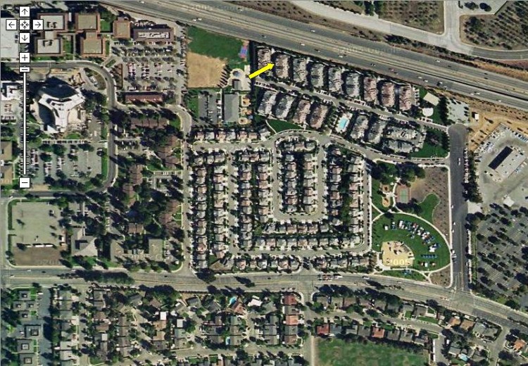
I just wanted to resurect this thread and point out that google now has satellite photos. It’s pretty fun to look at real photos of the places I ride and work. This is a lot like keyhole, but free and slightly less functional.
To view the satallite images, click the satellite link on the upper right menu on the google maps page.
Here’s where I live:
There is also TerraServer-USA which lets you zoom in on Aerial photos. TerraServer uses aerial photos from planes rather than satellite images. They’ve got color photos for select urban areas and lower resolution black and white photos for the rest.
Here’s the Golden Gate Bridge.
You USA folks are spoiled. Terraserver nor Google Maps cover Europe. Well, Google Maps cover the British Isles which some consider to be part of Europe but look how lonely they are in a big undefined blue ocean. Terraserver used to cover part of the Netherlands but not anymore so.
So now that we’re at it: anyone know of a free server for aerial or satellite imagery for continental Europe?
(I’m lucky to have access to web-based aerial photography ‘maps’ for my usual MUni area but it’s made available by the municipality (what’s in a word!) and so it doesn’t extend beyond the municipality boundaries.)
Klaas Bil
We’ve got the map and image data because it was funded by the U.S. Geological Survey with tax dollars. It is publicly funded and the data is publicly available. It is nice and I’m very glad the data is publicly available. It makes for some useful services like TerraServer-USA and useful GPS applications that can take advantage of that data to plot GPS tracks on aerial photos or freely available topo maps.
Other countries have not been so generous with their maps and image data. In some cases it is because that data was privately funded rather than government funded. In other cases it is because the government desires to sell the data rather than give it away.
TerraServer used to have image data for Europe but that was only temporary. There is info about that in their FAQ.
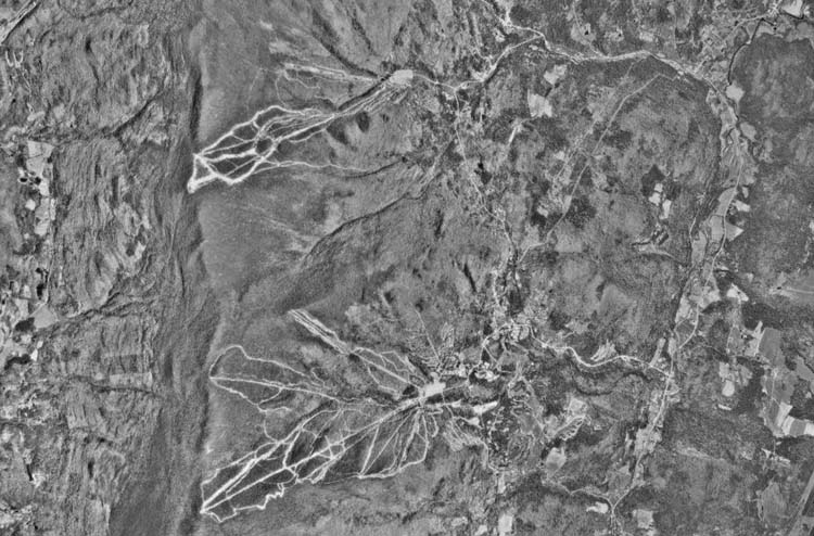
I’m pretty sure somebody here has mentioned it before, but if you’re a map geek like me, go to worldwind
and download the program- there’s LandSAT coverage for the whole globe and be sure to play around with the vertical exaggeration!
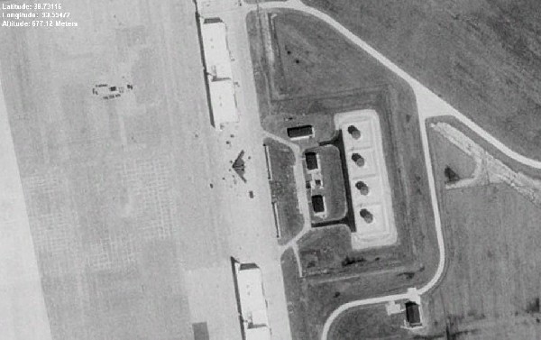
That’s a militiary issue to which www.vanuitdelucht.nl did adapt.
(but I was in time, and got the pics before they were masked, and so I am as potential terrorist as you can be)
Have a look right from the Central Station in Amsterdam for example
(the marine-basis which is the Dutch equivalent of the Pentagon and which housed Ayaan Hirsi Ali)
Or at Volkel or Gilze-Rije where there are more illegal nuke-bombs than were found in Iraq.
Actually those parts are US area, so that the goverment(s) can (and did!) deny having them.
(untill a group a anti-militairists ran into the base)
So, any interesting maps (so area51 excluded) in Google?
I really like this program, so much so that I bought a new graphics card just so I could use it properly. Unfortunately I do think it was better before they changed to the NLT dataset and discontinued the original visible / pseudo colour dataset. The resolution of the NLT images isn’t as good, and the colours look really weird and dark. The pseudo colour was much better, but now the community cache rarely has any places I’m interested in that I don’t already have.
Ho-hum. It’s still free, and hopefully the NLT dataset will get better…
Phil
I used to work somewhere that didn’t show on many aerial photos… there was just a green field instead. It was really nicely done, there were little paths criss-crossing the area and a little shed drawn in the corner… 
This is on WorldWind, I don’t know about google…
Phil
What’s with that? On all the “TIPS” links in the Den Haag page that I clicked, it looked as if something loaded but then a blank page was displayed. Do I need some software or plug-in?
Klaas Bil
Hmm- I wonder if that would help me- often when I use vertical exaggeration but e4specially when I use my right mouse button to tilt the perspective I get all kinds of wierd graphical stuff- triangles of green in the sky, images of the entire globe behind gaps in what I’m trying to see, stiff like that. I have a 2003 Vaio desktop right now- not sure what it is but I’m sure whatever video card it has isn’t really one of the best- what would you recommend?
I can’t imagen that I’ve done so, but yes, it seem like you have to install a plugin. It’s asking me to install (OK) or not (cancel). That’s were I choose cancel now. But I’m pretty sure it must be just a harmless java applet.
My aged Matrox G400 was alright when looking straight down, but if you tried to tilt down it would go as you described… strange lines and shapes obscuring the view, then if you didn’t go back to vertical it would hang the entire computer.
Something I found that helped a bit was to turn off layers you don’t need, like the Blue Marble base layer… it would become visible sometimes, and turn the entire view into a bluey-green blob rather than what you actually wanted to look at.
My new graphics card is just some ATI jobby; very much a poorly-researched impulse buy, but it seems to do the job… ![]()
Phil
Here you are; http://www.defensetech.org/archives/001511.html
Area 51 included.
And more: http://www.defensetech.org/archives/001520.html
Here’s a plane in flight
Thanks- that worked perfectly! I love cranking up the vertical exaggeration so my home state looks like the rockies!