Don’t know if this should go into JC really, but looking at the trivia there at the moment …
Anyway, I’m thinking of buying a GPS thingy for uniying and so on. Does anyone have any recommendations or comments? (Any new thingies that might not be in any other discussions of this topic that I might search for, for instance.)
I’m thinking something below £150 (about $240) and have been looking initially at the Garmin eTrex Legend. Anybody have any better ideas. Would a wrist thingy be better for instance?
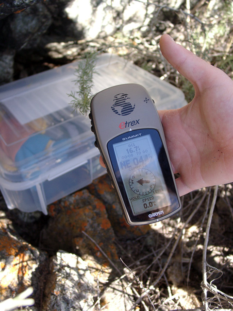
Any of the Garmin eTrex series will talk to your computer. I’ve got the very basic eTrex (about $90USD) and I like it a lot. The upgraded models are even better with more features but the basic model does everything that I need. Location, current speed, ave. speed, elevation, distance, tracks, routes, stores something like 500 waypoints, probably some other stuff I haven’t figured out how to do. I’ve got topo map programs and a data cable and can load routes and waypoints in either direction. A fun little passtime you need a GPS for is geocaching. Kind of an electronic treasure hunt game. Check it out at http://www.geocaching.com/
I think we’re definitely moving into JC territory here.
If I were to get a new GPS right now I think it would be the eTrex Legend. It’s very similar to my current Venture but with a much larger capacity for track points, which I think is perfect for what I want a GPS to do.
Don’t forget to budget for map software for the computer; the usefulness of a GPS increases tenfold when you can upload and download tracks, routes and waypoints rather than having to fiddle around on a tiny screen with that little stick thing!
Choosing which map software to use is probably harder than the GPS, unfortunately! I use Fugawi because it is the cheapest in terms of square miles for your pound, but it isn’t as feature-packed as some of the others and doesn’t have 1:25000 scale maps. Tracklogs is very popular with cyclists, but there have been problems with moving track files and whatnot between versions. Memory Map is possibly the most popular, but it is also one of the most expensive. I have looked into getting Memory Map for small areas of interest such as places I go regularly, but the whole of the UK is somewhat pricey. I think Loosemoose uses this so he would be a good person to ask for an opinion.
I know this may sound a bit odd to the techno gadget freaks out there, but what’s wrong with a map and a compass ? Never any problems with flat batteries.
To be honest I find the navigational aspects of a GPS secondary to the souped-up-cycle-computer aspects. If I don’t know where I’m going I’ll always take a map, but the GPS is great for distance, average and maximum speed, height gained and whatnot. Show me a compass that can do that!
I’ve got Fugawi. It’s usually available on Ebay at a good discount to shop prices - I think I paid about £70 in total for all of the mainland UK S of somewhere N of Edinburgh (IYSWIM!). It’s quite OK, but I don’t think you can upload maps from it to an Etrex (someone will correct me if I’m wrong). AFAIK you have to have the expensive Garmin maps for an on-screen display. You can of course download waypoints etc to the GPS from a PC, but you can do that with a very basic receiver.
Amongst my collection of GPS systems (which vary in cost from £35 to £25,000 for the posh one I’ve got at work) is a little bluetooth GPS which communicates with my PDA, to which Fugawi maps can be downloaded in chunks of about 100 sq km to give an OS moving map backdrop.
Another option for mapping is to use a package such as Oziexplorer (or the mapping version of Fugawi) which lets you scan in a paper map and calibrate it for use in a PDA or laptop display. Usual functions available for downloading waypoints etc.
It really depends on what you want out of a GPS. They don’t give stunningly accurate indications of speed unless you’re following a steady straight line for a reasonable distance. They’re handy for working out where you are relative to an on-screen or paper map. With an appropriate navigation package they’re great for route finding on the road network. They’ll tell you the time accurate to a few nanoseconds.
There’s a brand new development in GPS technology. It’s called “High-Sensitivity SiRFstarIII™ architecture”. This makes a tremendous difference when under trees (like many of our rides are). If you are buying a new GPS today, I couldn’t imagine getting one without this. My previous ones are Garmin eTrex Summit and ForeRunner 301. But my new one is Forerunner 305. The most amazing thing about these new GPSs is that they work indoors.
Another recommendation is to use a GPS that’s made for cycling rather than a general purpose one like an eTrex. If you are not interested in heart rate, then you want a ForeRunner 205.
Look at this article for a detailed example of how much the new SiRF starIII technology makes a difference under trees. All my old tracks look like the red ones on this page: http://tinyurl.com/kg2cm (zoom in on the comparison photos, especially the second one.)
Is there a list somewhere of which GPSes use this? I much prefer the eTrex design to the others for their versatility - I’ve used mine while unicycling, biking, walking, driving, canal boating and on trains - but unless they’re keeping it quiet I can’t find any that mention SS3.
I dont know much about this new technology but having a multi-directional antenna rather than a flat one can really help with trees, canyons, other obstructions and works better in a pack.
The 3 means in has heart rate and the 2 is a cheaper model without it. While the Edge models come with bike mounts it seems like you could use them anywhere.
A friend of mine has a SiRF III unit from Spark Fun. I think it’s this one (yes it’s barely bigger than a US quarter.) He has it integrated with mapping software from Delorme that runs on his Treo650 smart phone. He can see his dot moving on the map on his phone, even while indoors. Way cool.
This is certainly the way of the future - that’s why I said I can’t imagine buying a pre-SiRF III GPS. If what you want right now isn’t available, wait - it’s a terrible time to buy for you. But if you like one of the Garmin’s above, don’t wait.
In 2000, when SA was turned off, suddenly personal GPS got a lot more interesting and Geocaching started getting really popular. About the same time, really nice models like the eTrex from Garmin started appearing. We tried geocaching back in Jan 2001 and the GPS took us to within 16 feet of the cache. It’s fun but was sort of too easy, so we never did it again.
Another really cool thing I remember doing with my GPS was on my trip to Mexico also in 2001. I held it up to the window of the airplane and got a fix. The satellites said the plane was at exactly 37,000’ and the barometer said the cabin was pressurized to 6,200’. Having a separate altimeter not based on satellites is a really nice feature.