Two fantastic rides on the Quantock Hills, Somerset

I’ve been thinking about a trip to the Quantock Hills, about 35 miles away from here, since moving daaan saaaf last September but until the other week I’d never quite gotten around to it.

Two weeks ago I finally managed it, and wound up spending a sunday afternoon racking up 13 miles on the muni. I only took the 24" because two days before I’d put the new Big Apple on the 29er, and couldn’t be bothered to remove it already. I planned (very loose use of the term) my ride based on the OS map, which showed a large expanse of Forestry Commission land to the south, so I headed for that. Forestry Commission land is generally excellent for enjoyable and well-maintained trails.

I kept thinking how I should have made the effort to put the knobbly tyre back on the 29er… unfortunately the vast majority of the ride was on fire roads around the valleys, which made a 24" a bit of a slow beast to guide around. A 29er would have been a much better choice for the ride, being able to ride everything but the occasional super-steep bit with more speed and less leg-flailing.

The only time I ended up walking was on discovering the mother of all downhill courses; I would have been severely impressed by anyone managing to ride it as it looked positively lethal! As if the steep gradient wasn’t bad enough, some of the obstacles were extremely daunting… large jumps with no run out at all, or immensely tight, steep technical sections with a handy tree or large drop waiting to catch the unhinged.

The last section of the ride crossed the road into the northern section, after an ice-cream stop. This half is not Forestry Commission, and is much more open with more variety of trail sizes. Here the more nimble 24" came into its own! No fire roads to be seen, the tracks ranged from rocky doubletrack to super-fun singletrack winding down into the valleys.

This section made me want to come back and see what else was waiting to be ridden on this side, as I’d only scratched the surface. This I did last weekend, again taking the muni in the hope of more rooty, challenging trails.

This time I roughly followed a route I found in What Mountainbike magazine. It didn’t venture into the southern Forestry Commission land at all, remaining solely on the area to the north.

What a route it was! A fairly easy start along the fairly level top of the hills before screaming down to one side of the hills along a grass track, trying desperately to slow down to avoid catapulting over the rapidly approaching gate half way down. This was followed by a short section of singletrack amongst the trees along the bottom of the hills, bouncing down a very rocky track before beginning the long drag back up to the top.

This was the worst bit of the ride, and something I think I’d leave out if I were doing it again, even if it meant missing out on the fun previous section. It was too steep, bumpy and seemingly never-ending to ride, and in a sheltered valley facing the sun so was scorching hot. By the time I got to the top I was dripping in sweat and thoroughly knackered.

While stopping to get my breath back and eat sweets at the top a trio of walkers came past and we started talking. He had apparently seen two other unicyclists up there, one or two years ago; I’m guessing this is you, Paul and Sarah?

He turned out to be a keen cyclist who had done John O Groats to Lands End. He mentioned something that truly amazed me; that the record for the fastest JOGLE time is 1 day 23 hours. Is that true? That’s incredible! The AA website says it would take over 16 hours to do that by car, so on a bike that’s some serious cycling.

After that my route descended to the bottom of the hills again, this time into a wooded valley on the north side. This was the /really/ fun bit. The track starts out as a narrow groove winding its way through patches of gorse until it reaches the trees, and from there on down it’s a solid blast right down to the bottom. The track had everything, from excellent swoopy singletrack to log jumps, rooty sections and stream crossings nearer the bottom.

The stream crossings were great fun, ploughing through the water while other people stare in amazement (or possibly bemusement, but hey)… but they obviously got bored of making the track cross the stream, so for a stretch of about 30 metres or so you end up cycling along the stream bed. Truly mental… your feet and legs are getting wetter and you can’t see the rocky bed you’re riding along through all the splashing, so you have no choice but to keep going and hope you don’t come off! Excellent fun.

On reaching the bottom the route moves across to the next valley (past a little cafe - a few cyclists drying their feet in evidence!) and up to the top again. More watersplashes; there are several bits of path criss-crossing the stream most of the way up, so you can choose either to stay on one side and keep your feet dry or see how wet you can get.

The path then leaves the stream and gets really steep once more, although under the cover of trees so it’s not so punishing, and the rideable bits were much more fun than just a long slog upwards.

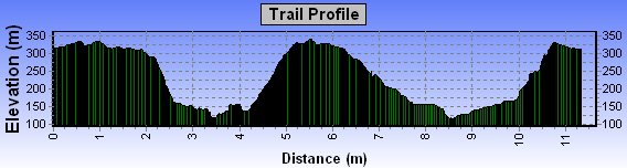
I got back to the car after 10 miles horizontally, but my legs felt that the vertical distance definitely wasn’t negligible.

The first ride was good, but the second was one of the best muni rides I have been on in a long time. I will definitely be going again… those last two valleys were just too awesome to be only ridden once. Or twice… or…

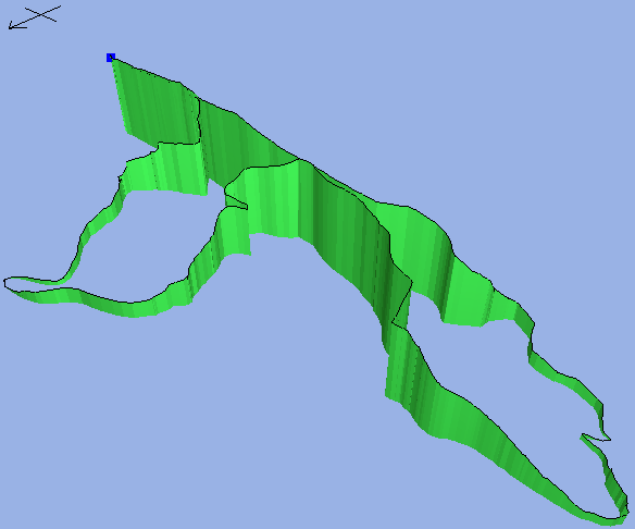
For the intrigued a map of the area is here. The hill to avoid is Bicknoller Hill, just off the left edge of the map. The really fun bits were Hodder’s and Holford Combes, the north-south valleys meeting at the top. The Forestry Commission land is to the south east, to the south of the road.

Curious: In Halfords yesterday (I went in for a tyre pump adaptor, I ended up looking at mountainbikes… how did that happen?) I noticed they had a helmet named “Furnace”. Given the extremely pleasant British weather of late, they can’t expect to actually sell any of these, surely? :slight_smile:

Phil

SOoooooooooooo Loooooooooooong…Must focus…aack! I give up.

Mind giving me a five line summary?

Re: Two fantastic rides on the Quantock Hills, Somerset

Probably. We had a good ride up there last year.
Some nice stuff in the Forestry - other stuff on the open
hills and in the Coombes. Good place to ride.


Paul

1 Not too long at all. It’s all in the attention span, you see.

2 On the day that Phil’s brother rode all my favourite difficult
3 bits on a Coker faster than me, Phil writes up a better
4 sounding ride than I’ve ever done.

5 But I’m not bitter.

That was five lines.:wink:

Re: Two fantastic rides on the Quantock Hills, Somerset

phil wrote:
> He turned out to be a keen cyclist who had done John O Groats to Lands
> End. He mentioned something that truly amazed me; that the record for
> the fastest JOGLE time is 1 day 23 hours. Is that true?

No, it’s actually less than that. The official record is 1 day, 20
hours, 4 minutes and 19 seconds, set in 2001 by Gethin Butler. The
previous official record, set in 1990 by Andy Wilkinson, was 1 day, 21
hours, 2 minutes and 18 seconds. AIUI the shortest route is 861 miles.

Andy Wilkinson still holds the unofficial record, at 1 day, 17 hours, 4
minutes and 22 seconds. Unofficial because his fully faired Windcheetah
recumbent wasn’t UCI legal:
<URL:http://www.windcheetah.co.uk/record.htm>

FWIW, the unicycle record is apparently 14 days, 12 hours and 41 minutes.


Danny Colyer (the UK company has been laughed out of my reply address)
<URL:http://www.speedy5.freeserve.co.uk/danny/>
“He who dares not offend cannot be honest.” - Thomas Paine

Sounds great Phil - nice description - any pics?

Simon

ENVY

I haven’t had time for a decent ride in ages.

Nice write up Phil and some rivalry for Mike? :wink:

Cheers, Gary

No pictures, unfortunately; I didn’t take my little camera, and to be honest it’s so rubbish that I probably wouldn’t have had any half-decent pictures anyway. One of these days I will find a digital camera I like… small enough to take on rides but not bank-breakingly expensive.

Today’s rain is probably my fault, sorry… the throwaway line at the end about “the extremely pleasant British weather” was just asking for it, really…

I’ve been playing with the GPS again. This is the elevation profile of the ride; the right hand side was the fun bit, and the uphill near the centre was the hellish hill.

Thanks for the comments everyone!

Phil

elevation.png

Phil, I’m interested to see that picture but it doesn’t show. I remember your earlier elevation profile plots, and that you wrote some software to evaluate GPS tracks in this way. Since I recently acquired a GPS unit (eTrex Vista) my interest has just soared to new heights. (I could draw an elavation plot :slight_smile: )

Klaas Bil

Edit: after I posted that it does show. Hmmm. But didn’t you make something to plot elevation in 3D? - KB

That would be this one…

I haven’t done very much with this since getting a “proper” mapping program. I’m currently ponderin’ about learning java so I can make it into an applet, that would be pretty cool.

Do you have software to get the tracks off the GPS in the first place? I’ve started downloading them with the mapping software and exporting them to this because of niggles getting my uploading program to work perfectly…

Phil

elevation2.png

There’s a 3d feature in the Tracklogs and Anquet software now which uses the OS map data as a texture map and uses the height data, so it’s as if the map has been pushed up underneath to show the contours. It looks really cool, way way cooler than just an elevation plot.

This is the skyline trail at Afan Argoed done like that.
<http://kluster.shitshifter.com/images/tracklogs%20pics/skyline%20route%20pic%2001.jpg>

As for cheap cameras, the one I’ve got (DSC-U20, or U30, U40) is now down to about £130 or £140. It’s only two megapixels, but does pretty good pictures for a 2mp camera.

Joe

That looks very cool.

The mapping software I have (fugawi) doesn’t do 3D stuff. When looking into the choices I tried the 3D view in Anquet, and thought it was pretty rubbish. It didn’t let the viewpoint leave the ground so you couldn’t really look around as much as you want, and it looked truly awful; it used a massively pixelised version of the map with little detail. Contour lines were invisible unless really close together, then the ground just went orange. You had to stand on the other side of the room to get the best view from it.

I don’t suppose you know if the OS map data can be moved between programs? Fugawi came with vastly more map than TrackLogs for the same price, but the TrackLogs software does sound good.

Phil

Well i might take my camera on the ride on sunday very small good pictures as well not sure of price though.
Ben

Re: Two fantastic rides on the Quantock Hills, Somerset

On Thu, 10 Jun 2004 12:43:57 -0500, “phil” wrote:

>That would be this one…

I’m offline while I write this, but I guess it is.

>Do you have software to get the tracks off the GPS in the first place?

Yes and no. I ordered MetroGuide Europe with it but they sent version
5 while 6 is out already. I’m now in the process of swapping (over
mail), once I have the new CDs installed then the answer is yes.

I don’t know if the Dutch equivalent of OS maps (Topografische Dienst)
is compatible. Nor do I know how much I’d have to pay for them. I have
digital topographic maps of all of the Netherlands already on a CD,
but I don’t know if that is compatible either. It doesn’t have
elevation data anyway.

I will have to find out a lot of things…

Klaas Bil - Newsgroup Addict

be sure to remove the saddle and simply sit on the seat post. this is far more comfortable - tennisgh22 on the comfort of Savage unis

Very cool indeed. It would be much cooler still in stereo view. Can the program change the viewpoint? Then try offsetting the viewpoint by a meaningful distance (maybe 10 - 100 m, you need 2 to 5 degrees difference in viewing angle) and look at both pictures simultaneously through a stereo viewer. That would be the ultimate in coolness!

I’ve done this with landscape photos taken sequentially from an airplane: amazing!

So, does the program allow the viewpoint to be set?

Klaas Bil

Yes… you can fly around it, move up and down, change the lighting angle etcetera. Yesterday I was having a play around with a demo version, from here: Classification - TrackLogs

Phil

Going slightly off topic, but my dad has a very small piece of threaded rod that fits into the tripod attachment of a pair of cameras, which combined with one of those push button on a wire shutter release things gives you great 3d pictures. I think he has two cheap second hand SLRs for doing it. If you’ve got two similar cameras this is a great way to do 3d pictures.

The real bummer about all these OS map based programs is that the data isn’t portable between them, so you need to pay for the map licences twice if you want multiple programs.

Joe