World Wind is a program from NASA that combines satellite imagery and altitude mapping to create what is effectively a 3D model of the entire world.
Just being able to see overhead imagery of every part of the globe is pretty amazing, but when you then lower the viewpoint and the mountains jump out at you in 3D the effect is truly staggering. All of the people I’ve shown this to have agreed that it is jaw-droppingly impressive.
NASA has to make all their data freely available, and this is their way of making it accessible and useful to the general public. The program is open source and the data is free; all that is required is a hefty graphics card and a fast internet connection, as the images and data are downloaded on the fly when you first look at an area.
Places in the US have the added extra of USGS data, also available freely. This includes more detailed imagery of the entire US, topographical maps and super-accurate 1 metre / pixel imagery of many urban areas. This really is awesome… you can see cars on the road and people in parks.
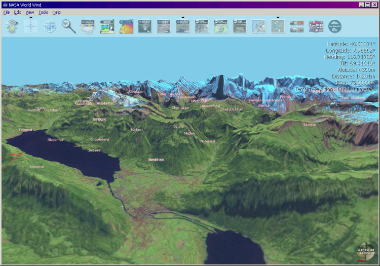
This image shows some of the Swiss Alps, looking south over Interlaken to the north face of the Eiger on the horizon.
Go try it! It’s definitely worth the 170MB initial download (there’s a BitTorrent tracker for it); hell, I’ve just bought a whole new graphics card so I could use it properly. “Free software” indeed…
All we need now is the Ordnance Survey to do the same as the USGS and release the data they’ve collected with public money and we can get this level of detail in the UK too…
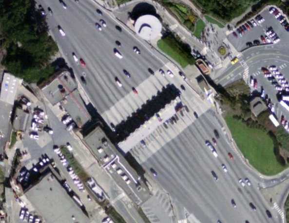
This is a really exciting picture of the toll booth at the southern end of the Golden Gate Bridge. You can’t make out car types but it isn’t far off…
Well, it’s actually still only a 2D picture, although it suggests being 3D because of the shading. Now go ahead and trick the software into creating two of these pictures of the same scene, whereby you shift the horizontal position by about 3% of the distance to some typical/significant features of the scene. Then look at the pictures through a stereoscope. I’ve done this with pictures of mountain landscapes, making two separate photographs 100 m apart or so. If you think that Phil’s picture is stunning, the stereo image is stunning squared!
The JPL servers are a bit wonky depending on what they’re doing at the time. Since February or so the program connects to servers elsewhere, so that’s no longer a problem. Although having said that I’ve never had any problems since I’ve been using it (last November).
The age of images being out of date I couldn’t care less about; the mountains I’m looking at aren’t going anywhere in a hurry Outside the US where you can’t see individual houses it’s not really an issue.
Keyhole is similar but different. For the US it’s much better; outside the US it’s a bit rubbish. It’s also a subscription service, unlike WW. It doesn’t do any of the funky animated overlays of hurricanes, temperatures and whatnot, which can be interesting.
I didn’t know it had been bought by Google, though. Bizarre…
In World Wind you can tell that all the imagery was taken vertically on steep slopes and mountains… seen from the side they look stretched because the satellite couldn’t see very much.
Even so it’s the ability to fly around the landscape that really brings it to life, rather than just a static picture.