I had already posted the following text in my blog and I’m too lazy to write it all again, so C&P:
Problem is, my programming skills are rather small. Also, I wouldn’t like to finance the server(s) all by myself (which OSM prefers users to set up), maybe a donating system would help.
So, anyone out there who would like to help?
And can I establish the hashtag #OSUM (Open Street Unicycling Map) right away? Or would OSMU be better?
EDIT: I forgot to mention, that not only would this give younicyclists (:p) the possibility to plan their tours ahead on their computers, but if anyone would take up the task to write an app, you could download the customized map tiles into that map app and use it on your smartphone.
From the German perspective, I would think that mapping or tracking the official bicycle routes would be sufficient for a start. I don’t know how well those systems are developed in other countries. (I’ve only taken my unicycle to Edinburgh.) But I guess, it would work there as well.
One problem I can see is people’s different perceptions of how hard and how dangerous things are. I know that some trails I’d have put down as orange a year ago I’d now put down as green. Even on streets it seems people have widely different views on whether the traffic is acceptable - that’s certainly the case among bicycle riders from my experience, so I doubt it would be different for unicyclists. You may not be all that happy riding some of my everyday routes!
I totally agree with you about the problem of different perceptions. But maybe a kind of rating system and reviews (including the experience level and type of unicycle used) and maybe photographs could help. But maybe that makes it way too complicated, I don’t know.
A rating system would certainly require some programming.
OR:
You type in your type of unicycle and your skill level and the color of the track changes accordingly.
I would be happy to just start the project on a small scale, but even then I would have to invest some money into a URL and server space. I’m gonna move soon, so I need all the money I don’t have (:() for that.
Maybe one could ask unicycle manufacturers for support financially? But one would need a kind of outline to show them first.
I don’t know. Probably? Apparently, I don’t know enough about OSM and how one can use it.
But anyway, you wouldn’t get the information about public transport conditions and so on.
About the difficulty ratings: the IUF will release an official muni difficulty scale together with the next rulebook iteration. It was developed by some of the top muni riders during the last rulebook committee. Hopefully, it can be released in the next few weeks.
Well, that could help, but I don’t have a muni and this was more thought for urban unicycling. But adding off-road tracks for munis could be an interesting option as well.
EDIT: Maybe one should be able to choose from “Beginner’s Map”, “Experienced Map” and “Muni Map” and everyone can decide for themselves whether they consider themselves Beginner or Experienced.
I hope to some day somewhat consistently ride an easy section like that :p:o
OP - There I believe, exists a rating system in place that compensates for different view points on difficulty for MTBers. Eg occational mandatory drops up to 6", rooty, optional drops up to X ft, etc.
Check out Skidmap.com . True it’s a mountain biking site, but it lists many local rocky mountain trails (mostly Ut ). The thing that’s cool about it is that you can look at trails based on their difficulty, construction, and current condition. Many of the better trails include a little synopsis of what to expect and pictures.
I have found that my skill level allows most MTB trail ratings to apply to my riding as well. If it’s rated intermediate (blue) I find it intermediate for me, and therefore enough crunchy stuff to be fun, but not so easy it’s boring. If it’s rated advanced, I expect to be able to ride most of it, but with some areas requiring hiking and the riding will take more time due to the technicality or strenuousness.
Apparently, I didn’t make myself clear. Or this thread is only read by municyclists.
This idea wasn’t actually meant for municyclists and their quest for the most challenging tracks in the world. Instead, it was meant for unicyclists, who like to explore cities and long distant bicycle routes on their unicycle.
It seems obvious to me now, that the municyclists out there have their maps and websites to help them find their way. And it is great for you that you do.
Maybe this is a beginner’s perspective and a perspective of someone living in Berlin with its many official bicycle routes and parks.
Hoping that I didn’t offend any municyclists, I continue waiting for responses from “people like me”
Or simply majority of unicyclists who visit these forums ride mainly muni
Anyway, I love the idea! It’d be really great to have a map like that. However, it’s gonna be quite a challenge to make it happen. There are so few riders and they’re spread around the world that most likely, I suppose, not many cities or routes would get covered properly. I don’t know about germany though, there are probably 10000x more (distance) unicyclists than in Finland (or in Scandinavia) so there it might actually work
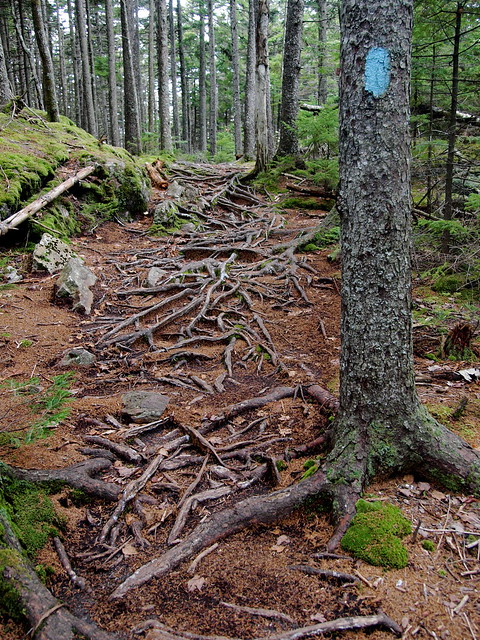
I’m guessing that the bullet points in the original post caused most people to think that you were referring to muni. For example I know that I associated phrases like “rather bumpy” with trails that have lots of rocks and roots. I guess you have some fairly gnarly sidewalks in Germany.
Another thing that caused me to immediately think muni is that while all sidewalks, roads, and greenways are unique I can’t imagine that the differences between most sidewalks are large enough to merit multiple difficulty rankings. Trails on the other hand…
Not to belabor the point but another thing that got me thinking muni is that if one were to create a website to rate riding locations it seems like a list of singletrack trails would be manageable while the possibilities for road and sidewalk routes would be overwhelming.
I think I’d rate sidewalk and road rides in terms of climbing grades and expected traffic as opposed to the degree in technical proficiency required. I’ve used http://www.mappedometer.com/. You can plot out the course you want to ride and get the distance and elevation but it won’t give you the condition of the streets. You can also save and publish routes for other people to see.
I’m not using the forum that much, because I consider forums such time wasters, although they do have their merits (if that is a good word to use in that context). So I didn’t know that it is mainly used by municyclists. Sorry to have lead you all up the bumpy garden path.
I’ve been using gpsies.com, which has very similar features like elevation and distance. It also lets you choose from a range of map material.
I agree that “my” rating system is somewhat faulty or rather insufficient. The elevation would have to play a part in it as well. In Germany, you have to use the sidewalk with your uni and aren’t allowed on the bicycle track, although the cycling tracks are usually smoother and have lower kerbs/curbs. I personally can’t handle kerbs/curbs higher than lets say 6 cm (2 inches) (yeah, mock away…), so I think this could be added to the textual description of the track/sidewalk. I usually switch to the cycling track anyway, hoping that the police don’t know the rules. Or even the street, if it is a quiet one…
The last tour I unicycled, cars were parked over the whole width of the sidewalk and I guess it is a habit in that area. That could go into the description as well.
All in all, I think it might be a way too ambitious project, so I’m gonna start a simpler version where people can use iframes to include “their” experiences, a bit like a wiki. This means that I won’t have to host any map tiles. It will still be a lot of work and support would be much appreciated.
I like this idea (At least to start off with - Maybe the editors of the Wiki could upload .png’s of a map off google/openstreetmaps and see how it goes from there) And will gladly contribute an article or two of where I live once I get better at riding (I’m still stuck on the ‘can’t go any further than my own street’ stage)
 ). The thing that’s cool about it is that you can look at trails based on their difficulty, construction, and current condition. Many of the better trails include a little synopsis of what to expect and pictures.