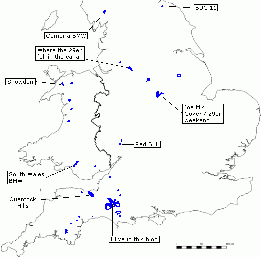
One of the best things about riding with a GPS is the permanent record of where you’ve been. Since getting it I think I’ve only ever done a long ride without it once, because the batteries ran out. It’s interesting to see how the miles soon add up all over the country.
I could spend hours playing with GPSes and maps. Oh wait, I do…
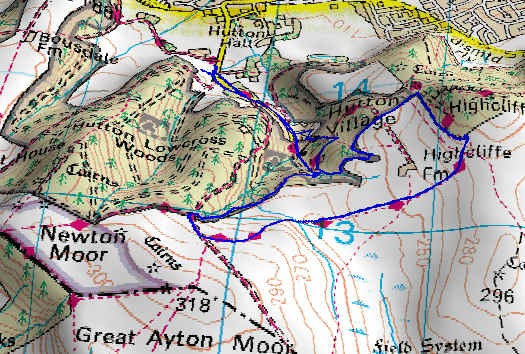
I haven’t had my Foretrex GPS for very long so I don’t have many tracks yet but I do have one from the BUC12 Muni ride that you don’t have Here it is in glorious 3D.
I try to keep all tracks that go somewhere I haven’t been before, whether by foot, unicycle, bike, car, train, canal boat… slowly but surely England and Wales is turning blue. (Scotland is just too far away!) It’s quite interesting to see which bits of the UK I’ve been to; it looks like I should visit the south-east more often, I only have a solitary line over to Winchester in that general direction.
Gary: The track-overlaid-on-a-3D-map is something I can’t do. I’ve tried it with World Wind, but it had problems with differences between the height of the track and the height of the ground. Does TrackLogs deal with this okay, or does the track go underground or fly occasionally?
Andrew: When I was looking at moving to Sydney I was a bit shocked as to how many times you had to click the “zoom out” button before Brisbane appeared at the top of the map. On the atlas they’re practically next door! How far can it be…
On Sun, 8 May 2005 22:48:06 -0500, “Evan Byrne” wrote:
>Garmin E-Trex
I have the E-trex (Vista) too. It’s nifty and small. But I think
reception quality in modelately difficult terrain (light leaf cover,
city) is sub-par. I would reconsider if I were to buy again.
Klaas Bil - Newsgroup Addict
“When it comes to the family jewels, you won’t be having fun until they’re having fun. - Jake D”
World Wind is one of the few GPS related software packages I haven’t used (yet) so I don’t know much about it (but probably will do soon). I tried Tracklogs but didn’t get on with it, that image I posted was from OziExplorer 3D. The elevation of a track can be slightly (but only slightly in my experience) different from the track to the map elevation data but OziExplorer can draw the track on the 2D map before exporting it to OziExplorer 3D as I did in that image.
I’ve been evaluating tons of GPS software packages and yet I still can’t decide which ones I like the best, they all have quirks that annoy me. There are some that I don’t like such as Tracklogs and Memory Map but all the ones I’ve tried seem to be someway behind the times as far as software goes, they have a retro feel.
My next port of call is GPS software on Linux, anyone have any pointers?
I have a Garmin Foretrex 201 which I’ve found to be very good for unicycling. You wear it on your wrist so it has a decent view of the sky and you can look at it easily while riding.