CLASSIC COLORADO UNI RIDE
COPPER TRIANGLE 2007
On Saturday August 4th, 2007 the 2nd annual Copper Triangle event took place deep in the mountains of Colorado. The famous Copper Triangle loop ride has long been considered one of Colorado’s classic alpine road rides. Graced with breathtaking scenery, gorgeous roads and four challenging climbs, the Copper Triangle exemplifies cycling in the Colorado Rockies. The Colorado Cyclist Copper Triangle course is a spectacular 80-mile loop cresting four Colorado Mountain passes - Fremont Pass (elevation 11,318’), Tennessee Pass (elevation 10,424’), Battle Mountain (elevation 9,253’), and Vail Pass (elevation 10,666’). The course passes three ski areas and is littered with historic mining outposts and camp Hale, the training ground for the famous 10th Mountain Division.
As with most of the big rides that I participate in, there is a foundation that is the beneficiary of the event. Major sponsors come in and create a friendly, safe, FUN environment for all of the participants. The “Davis Phinney Foundation” truly benefits from this wonderful event. Last year’s inaugural ride of the Copper Triangle raised more than $32,000 for the Davis Phinney Foundation with a total of 2,176 cyclists from 35 states across the country. This year the goal was to raise $100,000. Remember the American 7/11 Pro Bicycling Racing Team, then you must remember Davis Phinney, he’s been counting his victories for more than 30 years; first as the record holder for the most cycling wins in U.S. history, and most recently as a formidable contender in his daily battle against Parkinson’s disease. Even after his life-altering diagnosis with young-onset Parkinson’s disease at age 41, Davis has continued to focus on the many positive aspects of his life, and is encouraging thousands worldwide to do the same.
My day started at 4:15 am with the anticipated alarm going off. I had no problem waking up at that hour, I was very anxious to get up and begin my EPIC adventure. This was to equal my longest ride ever, at 80 miles. As a matter of fact, I have ridden this loop before, back in 04’, one week before NAUCC 04’, when I won the Marathon by almost 2 minutes. But, back in 04’ I was younger, and had trained harder for it. In addition, my start and stop points were in a different town, and I went the opposite direction in 04’. The opposite direction turned out to be a major difference, as I would find out later in this ride. Copper Mountain Ski Area was the start/finish, and we would go clockwise this year. I pulled into Copper Mtn. with other early event participants, trying to find parking. That wasn’t so easy, as it was still dark, and nobody was really awake yet, including me. I park my truck, crank up some Slightly Stoopid, and begin to get it “all” together. The 7/11 coffee is beginning to take effect, along with the loud music; I begin to awaken to what is about to take place. Even though the ride is fully supported, I still fill my camelbak with all the necessary supplies needed for a full day adventure. It is kind of like preparing for a backcountry ski trip, whether your going for a day of five days, you still need all the same supplies. I pump up the 36er to around 55-60 psi, check my seat pressure, put on the camelbak, wow- it must way 35 lbs (16 kilo), and off I pedal into the darkness. I see flashing red lights in front of me, I assume that they know where they are going, so I follow them. Sure enough we end up in the village, at the base of the ski area. There is no “official” start of the ride, you go when you feel ready, but there is a start/finish banner, I find my way over to it. I dismount and ask a fellow participant to take a photo, we swap photo taking, and the moment has come to “get er done”. I talk to a couple of the volunteers, and tell them as I spin away, “See you in 10 hours”. I get to the intersection of the highway we turn onto and there are multiple highway patrolmen there on their motorcycles. I think that, that would be really fun to escort 3000 bicyclists, and 1 unicyclist, over 4 classic Colorado mountain passes, what a sweet way to spend the day. They had just ok’d us to go onto the Highway, those w/o headlights anyway, as the first light was just a glimmer in the eastern sky. I knew that actual daylight might be delayed a little, as the Ten Mile Mountain Range was towering above us to the east. Very little noise was heard as I spun my way out of Copper Mtn. around 5:30 a.m. All of a sudden, a disturbing noise echoed loudly back to me, from the pack of riders just in front. As a passed a women, stopped on the side of the road, I noticed her rear derailleur embedded in the spokes of her wheel. I asked if I could help, and she said her partners were dressed in green jerseys, and gave me their names. A mile or so up the road, sure enough two guys in green jerseys were stopped, I gave them the bad news and I continued on. Made me feel good about how simple unicycling is, less parts to break, and less tools to carry.
This ride begins with 5 miles of gentle rollers, and then Fremont Pass begins in earnest. I felt really good those first 5 miles, I was passing a few riders, and I was being passed as well. I happened to turn around to see the traffic, as I was getting ready to pass a group of riders. As I turned around to see, I was pleasantly surprised to see what was the start of a spectacular sunrise. The Colorado High Country had seen quite a bit of rain the previous week or so, so we had some low clouds hovering in the valley that we were riding up. The vibrant orange/red mix was taking over the sky above us. That coupled with the low clouds, and the high mountain peaks above the clouds, made for an unforgettable start to my adventure in the Colorado High Country. About the same time as the sunrise was blessing all of us riders, the real work was about to begin. Fremont Pass was looming ahead, the steepest part of the climb is in the first 4 miles, (6.4km) where most of the 1600’, (488 meters), is climbed. After that tough section, the rest of it is much mellower.
I changed something in my gear just before this ride, something that I don’t recommend to anyone, but I did it anyway. I have always done all of my epic adventures with 170mm or longer cranks. After reading about the shorter crank benefits, I decided to try it. I had my 170mm Kookas drilled to 120mm, 145mm, and of course 170mm. I had one pretest ride with them at 145mm and felt like I would try it. I was sprinting up the first pitch, well maybe not sprinting, but was going at a good cadence. I was passing most of the bicyclist that had just passed me. I liked the 145’s so far; felt like I had good torque, and when it would flatten out, I could spin really fast. The sunrise was still brilliant, and the first sun on some of the 13,000’ –14,000’ (3962 – 4267 meter) Peaks was breathtaking. Oh yeah, the temperature couldn’t have been any nicer, it was around 50F, (10C), so I was riding in shorts and a short sleeve jersey. My heart rate was where I was hoping it would be, around 150bpm, with spikes to low 170’s when passing bicyclist. I would label Fremont Pass, 11,318’, as both being “unique” and “excellent”. Encompassing the summit of the Pass is the massive Climax Mine. The mine is a huge operation, (Molybdenum), that is eating away at the surrounding peaks, and the immensity of the facility is mind-boggling. What also makes it a unique Pass is that there are no switchbacks, the road has some curves, but the classic switchbacks are null. As with all Colorado Mtn. Passes my favorite “excellent” component is the scenery, and Fremont Pass has its fair share of scenery as well. You can see multiple mountain ranges from the summit, and there are a couple of high mountain lakes shining away. The first of four passes was complete; I took some pictures from the summit and headed down the south side towards Leadville. I averaged close to 8 mph on the climb.
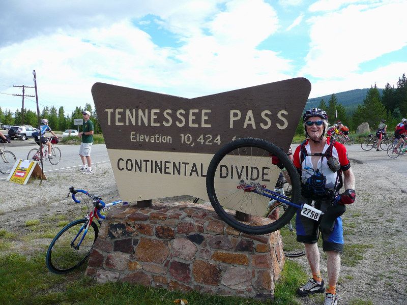
This is when the 145mm cranks really proved to be valuable. I had no problem controlling my speed, 14 mph, (22.5 Km/hr) on the descent. There are a few sections that are steep, and that were a challenge, but still I found myself spinning away. This is also where the masses of bicyclists began to pass me at speeds up to 50 mph (80Km/hr). I could hear them coming up from behind me, it was actually really cool to witness. So, for the next 5 hours I had bicyclists surrounding me. We pretty much took over those highways that day; it would have been a tough day to travel by car. A steady stream of bicyclists, and me, for hours and hours on the highway. There was approximately 15 miles, (24 km) of flat or even slight downhill after the descent, until the start of the next Pass, Tennessee Pass. Once again the 145’s proved to be valuable, as I made incredible time, just over 12mph, (20 km/hr). The day was turning out to be a classic Colorado day, bluebird skies, an ever so slight cool breeze, and that nice sun. I began running into lots of friends, locals, and bicyclist that I have met over the years doing these crazy events. I was feeling good, and was really having fun. The two tallest peaks in the state, Mount Massive, and Mount Elbert were off to the Western horizon. There 14,400+’ (4,389 meters) tall peaks popped out above the low eidolic clouds, and kept my motivation high, as I was riding towards them, so they kept getting closer and closer. Leadville is located at 10,159’ (3,048 meters) above sea level, (which I believe is the highest incorporated town in the USA), and is surrounded by the tallest peaks in the state. It is rich with mining history and the earth is riddled with hundred of miles of mines. The tour took a right hand turn at Leadville, and headed north for the longest leg of the triangle. This leg would include two Passes, Tennessee and Battle Mountain.
I continued to ride well and had many a conversation with the bicyclists, as we enjoyed the wonderful day together. I made a stop to rest the bum and just be. A few minutes later I found myself back on the GB4 36er spinning and grinning. Tennessee Pass from the Southside is much much easier than the north approach. I only had 7 miles, (11 km) to the summit, with really only 3 miles, (5 km) of that sustained climbing. This would be the second of four passes that I would climb today and I felt like I was doing fine. The high cadence of the pedals started to wear on me though, so I slowed it down a bit. After all, this was not a race, but an adventure. I was really glad to see the pitch of the road go up, I was looking forward to bagging another pass. As I hit the approach, I began to pick off most of the bicyclist that had picked me off earlier. I sprinted around a left hand corner, and there was the summit. I gave thanks as I hit the summit flying high J. I entered the aid station to refill my camelbak, and it was like Moses parting the waves. Hundreds of people moved to the side to let me by, I wanted to ride all the way to the station. For the next 5 minutes the questions and comments came my way hard, all good positive feedback. I did have one fellow tell me that, “ Superman use to be his hero, but not anymore”. Then the “How do you go downhill?” questions started up. This is when I realized that I had the hardest downhill section of the whole day to come, starting with the many switchbacks down the north side of Tennessee Pass. And, after all that downhill, I still had a small Category 2 climb, and then the final HC climb to finish the ride. At this point I had gone 33 miles, (53 km) and had summitted a HC Pass and a Category 2 Pass, in just over 3 hours total time.
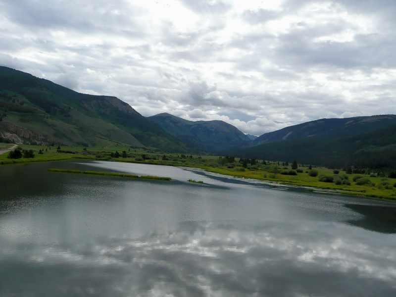
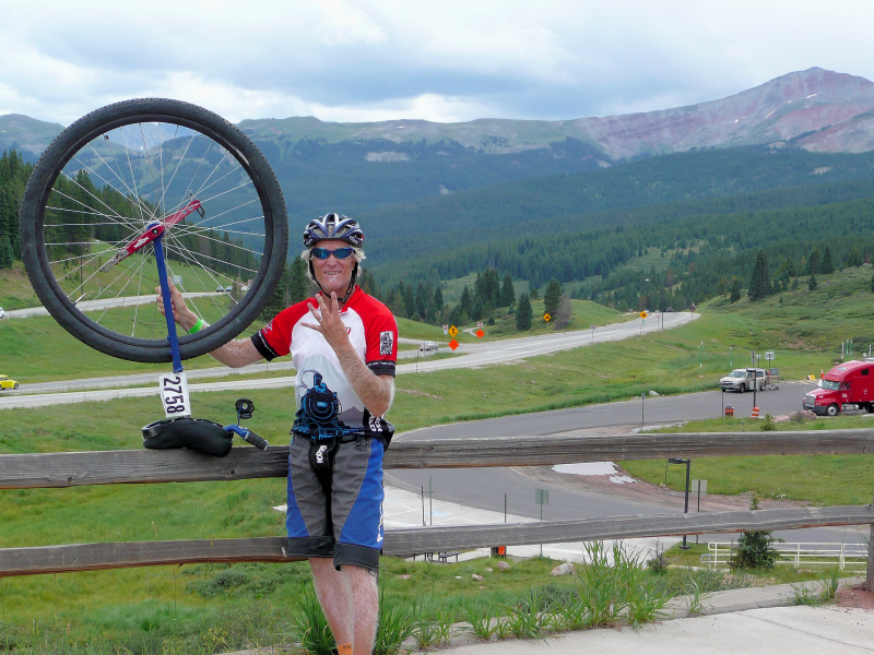
The weather was starting to make that daily afternoon transformation, from bluebird skies to puffy cumulus clouds building overhead. The temperature was still very pleasant, in the 50’s, (10-13C) and the thermals were starting to blow around. The next leg of the journey was ALL downhill, 12 miles (20 km) of sustained 5-8% grades. This section takes you down through Camp Hale, where the Army’s 10th mountain division trained high in the mountains for winter battle in the Alps during WW II. Some signs of the camp are still in the valley, and one can imagine what it must have been like to climb and survive in these mountains, carrying guns, heavy backpacks, and antique ski gear, WOW. I made another stop as my right knee was starting to hurt. Also, my toes from hanging on to the pedals were a little cramped as well. This was the ½ waypoint of my ride, distance wise. The gradient of the road the next few miles were not as steep, which made the knee feel normal. But, up ahead was the next pass of the day, Battle Mountain Pass. This would be the lowest elevation pass of the day for me, but I knew it would still kick my ass. Upon riding to the approach you cross over a classic bridge over a steep ravine, the Eagle River. It was really breathtaking as I rode over it, close to the edge, trying to look down to the river below. I fueled up as I started the climb. Boy, my legs felt really good, as I was finally using a different muscle group, enough of the downhill already. I began passing more bicyclists, but at this point of the ride, there were fewer and fewer of them. I knew at some point during the last ½ of the ride that I would be by myself, and that was beginning to occur. This Battle Mountain Pass, only 3 miles long, was very hard. This was due mostly in part to the double fall line of the road. I couldn’t ride in the center of the lane, which seemed to have less canting. It was both steep and canted for the extra challenge. One guy was saying, “I can’t believe I am being passed by a unicyclist” as a passed another fellow. As I passed this fellow, he was like; “there’s no way in hell that I am going to be passed by a unicyclist”. He passed me, but before the climb was done, I had re-passed himJ more downhill, from the summit of Battle Mountain to I-70 bike path. OMG, this downhill about did me in. Steep, sustained downhill with multiple switchbacks. I was really looking forward to the flats or even better, climbing again. The town of Minturn comes up, another nice break, this time by the river, very refreshing. I hit the bike path at the intersection with I-70 and made a high speed u-turn to continue on the trail; I barely made it without going into the river below. Two of the three legs of the triangle are complete. So far, I have ridden 55 miles, (92 km), summitted one HC Pass and two Category 2 Passes, all in 6 hours & 15 minutes. I had 25 miles, (40 km), to go with one big mountain still to climb, Vail Pass.
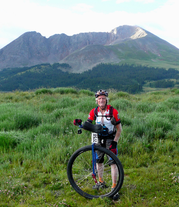
this is 1st pass - fremont pass
END OF PART I