Cycle computer vs GPS

So as not to hijack the Laos threads, I’ll start a new one. I’d been thinking of getting some sort of cycle-computer, but then I saw Nathan’s graphs from his Forerunner GPS which have speed, heartrate and altitude. Whoa!

Does it measure speed accurately? Because, holy cow, it would be cool to see all the data that Forerunner hacks up when you finish a ride! Why bother with a cycle-computer at all?

Cycle-gadgets are cheaper, right? And I suppose if one prefers the device on the machine rather than the wrist.

Please discuss.

Hello Stevyo,
I have the Garmin Foretrex 201 which I’m happy with. I chose the Foretrex because it has WAAS which is more accurate than the forunner. It often say’s 19 feet accuracy. I think elevation is less accurate on these devices, but I don’t how what the elevation accuracy is.

It’s handy on your wrist, you can check the display and change the settings easily.

There is a lot of function to these devices that I haven’t used.

I wish I always wore it. 2 weeks ago, I wondered from the park into a neighborhood, got turned around and came out 5 miles from the park. It was 38 degrees F and I had not worn a coat, just a T-shirt and jeans. I had left the unit in the car. I was freezing. I’m sure I could have back-tracked on the map to find my way back if I had it.

The computer interface isn’t documented well, you’ll need to track that down. I got the interface to work once, but the trial software I used expired and I didn’t want to spend the cost $50. Maybe someone will recommend a good cheap, or free program.

I’m no expert on this device.

Amazon had the best price I could find.

I just noticed, Garmin has introduced the next generation 205 an 305 units.

The new GPS units that include heart rate monitoring and other fitness features are cool. Something like that is going to be on my want list sometime soon.

But GPS does have limitations. It will only give you decent accuracy for speed and distance when it can get good reception. At times it will not be able to get any reception at all which means that it is only guessing or not displaying speed or distance at all while it is out of reception.

Things that affect reception and accuracy are satellite geometry in the sky (which is of course constantly changing), buildings nearby (reception in a downtown area with skyscrapers will be more difficult than in areas with lower buildings or no buildings at all), trees overhead, how many leaves are on the trees, how much rain is on those leaves, fog, rain, snow, how the GPS antenna is oriented, you body can even block the signal. Putting your hand over the antenna can be enough to block the signal. So there is lots that can affect accuracy and even whether or not you’ll be able to get a lock on the satellites.

If you’re really interested in instantaneous speed readings and accurate speed readings then a traditional cycle computer that has a magnet on the wheel will give better results.

If you’re looking at GPS units now it is better to go with one of the new models that includes the newer and more sensitive GPS chips. They have better signal reception and better battery life. For Garmin units that new chip technology is by SiRF. Here’s Garmin’s Press Release about the SiRF chip. You’ll have to dig around to find out which of the newer Garmin units are using that chip.

For accuracy the number that the GPS units report as accuracy (like say 20 feet of accuracy) is just a guess based on satellite geometry in the sky and not anything to go by. The actual accuracy could be very different. Again, that number is just a guess and not something that you should go by.

GPS units don’t always do a good job by themselves for altitude or elevation info. Their first priority is to get the 2D location right. The 3D info (elevation) is secondary. 2D location is going to be more accurate than the elevation. So if the unit says you’ve got 52 feet of accuracy you can figure that the elevation accuracy is going to be worse than 52 feet. 2D location requires a lock on at least 3 satellites. 3D location requires a lock on at least 4 satellites. If you want more accurate elevation readings you should get a unit that includes a barometric altimeter that supplements the GPS calculated elevation readings. The barometric altimeter will continue to get readings even if there are no satellites in view and its accuracy is also better.

Garmin has a good description of GPS technology.

WAAS is nice but it is not guaranteed to always make the GPS reading more accurate. At times it can actually decrease the real (as opposed to the reported) accuracy. WAAS will only improve the accuracy if the WAAS satellite is in view. The WAAS satellite sits low on the horizon so it can be easily blocked by trees, buildings, cliffs, etc. If you’re in an area where you are not likely to be able to pick up the WAAS satellite it is best to turn that feature off. Out in the ocean or up in a plane the WAAS works great because it is easy to see the satellite. In the woods or in the urban jungle, WAAS is less useful.

Knowing what is going on with GPS and how to use it correctly quickly gets in to technical matters. To use it correctly you need to know how it works along with where and when it will or will not work.

I have an old Garmin Vista. It frequently loses satellite lock due to tree cover when I go on muni rides. It also loses the satellites at times when I go on Coker rides. It uses the older and less sensitive GPS chip. The new SiRF chip should do better, but I haven’t used a GPS with that new chip yet to compare.

The “Edge” is supposed to be the sh t for bicycling, from Garmin. It’s new.

Thanks Ken, JC, and Mike! I’ve been reading up on these, and I’m still not sure I want one bad enough to part with the $ yet.

A smaller unit would be my highest priority. When they can get cell phone, camera, GPS, altimeter, a tire pump and maybe a good juicer all in one unit, down to a wristwatch size, I’m getting it!

Yes, they can get expensive. Especially if you get a GPS that supports mapping cause then you have to buy the electronic maps to load onto the GPS. Then there is the other gadgets that you’ll get for the GPS, a holster or a pouch, rechargeable batteries, etc.

Then after you get it you’ll discover that GPS software on the computer is generally frustrating to use. Most of the programs use a different format for exporting and importing data so getting data to and from different programs is more difficult than necessary. The UI on most of the software programs is poor and frustrating. I generally end up swearing and cursing when I have to do manipulation of GPS data on the computer. I think most GPS software for the computer is written by apes. Even the commercial stuff is lacking.

sport tracks. My favorite non-obvious feature is the “export to google earth” but it’s packed with useful features.

Cabela’s price matched the Amazon price. Other retailers might also.

-mg

I was tired of breaking cycle computers, so I decided to get a GPS instead. I got the Garmin Foretrex 101 (around $130 I think).

While I don’t regret the decision, it has the following issues:

Since mine doesn’t have rechargable batteries, and I only get about 12-14 hours from a pair of AAA batteries. Cycle computer batteries seem to last forever, and you don’t have to remember to turn them on or off.

Doesn’t work in heavily tree covered areas or on very overcast days.

Unreliable top speed!! Since I like to go fast, it’s a bummer that the top speed reading is really only an estimate.

Still, its nice having something that’s less likely to break since I wear it on my wrist, and I love all the extra features.

That is cool.

so yours weighs 2.6 oz and the 201 (rechargable) weighs 2.75 oz.
Does wearing that weight on your wrist get cumbersome? Can you switch wrists?

It won’t work in your pocket, right?

I hardly even notice it. Its just like wearing a bulky watch. I don’t see why you couldn’t switch wrists, but its a non-issue to me. …I haven’t tried it in my pocket, so I can’t really say. It would be hard to read it that way!!

A GPS generally doesn’t work well when kept in your pocket or even when stashed in a pocket of a backpack. The problem is that they don’t get good reception in your pocket or other pouch. Part of that is because the fabric and your body will block part of the signal, the other part is because the antenna is usually not oriented optimally when just stashed in a pocket.

The main thing that blocks a GPS signal is water or moisture. Your body is made of enough moisture that it can very effectively block the signal. Damp fabric can also block the signal. Damp leaves in trees can block the signal. Green leaves are also full of moisture. Rain on leaves is even worse.

The other issue is keeping the antenna oriented for optimal receiving of the GPS signal from the satellites.

Most of the small GPS receivers use a patch antenna. A patch antenna is about the size of a small postage stamp. It gets the best signal when it lays flat, like a piece of paper on a table, with the surface area of the antenna exposed to as much sky as possible. If you want the best reception with a patch antenna you want to keep the GPS unit oriented so that the patch antenna is looking straight up at the sky. That generally means that you want the screen of the GPS also looking up at the sky cause that is also how the patch antenna is usually oriented.

The other type of antenna is a quad helix. GPS receivers with a quad helix antenna often have a nub sticking out that is the antenna. A quad helix antenna gets the best reception when it is pointed up at the sky like a radio tower. That generally means that the GPS receiver should be oriented so it stands up like a skyscraper cause that is generally how the quad helix antenna is oriented in the GPS receiver.

My Vista GPS receiver has a patch antenna. I keep it in a pouch strapped to the shoulder strap of my hydration pack. The GPS is on top of my shoulder oriented so the patch antenna is looking up at the sky. That means that my head is blocking part of the sky so it is not ideal, but it is plenty good enough. If I was more fussy or more concerned about reception I could put it on top of my helmet so that my head wouldn’t block part of its view of the sky, but that wouldn’t be terribly practical. But there are some folks who do mount an external antenna on top of their helmet or hat so that they do get better reception. And if you are really in a bind and need to get a reading you can put the GPS receiver or an external antenna on a long long pole and extend the pole up through the tree cover till it gets reception. But if you have to resort to that while on a unicycle ride then you’ve got other issues that need to be addressed. :wink:

I’m not sure how those Forerunner units do with being strapped on a wrist. That means that they’d be sometimes oriented OK and other times oriented badly for best reception. It would seem that their reception quality would depend on how you hold your arm most of the time.

Re: Cycle computer vs GPS

On Thu, 9 Feb 2006 21:50:16 -0600, john_childs wrote:

>If I was more fussy or more concerned
>about reception I could put it on top of my helmet so that my head
>wouldn’t block part of its view of the sky, but that wouldn’t be
>terribly practical.

This is what I do with my Garmin Vista. I use the GPS mainly to record
my track, for later uploading to a PC and then to import into Excel. I
used to carry the Vista on my belt, but reception improved
significantly on the helmet, mainly important for leaf-covered areas
(and seasons) though.

If I would use the GPS a lot for wayfinding (as opposed to tracking)
the on-the-helmet position would be less practical, although I still
can pull the receiver out of the holster, fiddle with it / look at it,
and put it back, all while riding.

You can’t do things like this with a cycle computer…

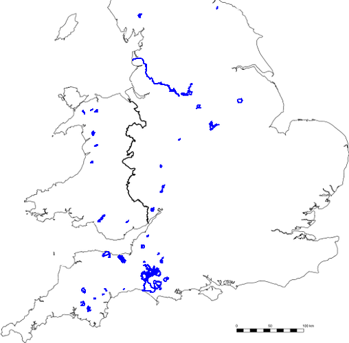
Or this (this is the main reason why I love my GPS; slowly but surely I am turning the UK blue with the places I’ve been…

What system do you have which enables you to do that phil?

Cathy

Ah, I’m not the only person of that opinion then…but…

Where has this piece of software been hiding?

My GPS doesn’t leave a blue line behind me while I’m riding – is it an optional extra? And is environmentally friendly? :wink:

The first picture is a track loaded into Google Earth; that is the top end of the Howden Reservoir in the Peak District with the Cut Gate trail heading up over the top.

The second requires a bit of fiddling; it is a screenshot of the program I use to store all the tracks (Fugawi) with the background map removed in a paint program and replaced with a picture of the outline of the UK. That is from the end of January this year; I have a few of them since I first got the GPS and it’s quite interesting to see new blobs appear and existing ones get larger as I ride in new places…

Another image that the GPS has made possible is my map of the Quantocks (670k gif), with the tracks of every single ride I did there. I still didn’t find every last trail, but I like to think I came close…

Phil

I don’t know. Last time I looked at SportTracks it was just a log book with not many extra features. It fell off my radar since it didn’t do what I wanted. Now it looks like it does much more. I’m going to have to take a new look at it.

The GPS software area has been in desperate need of some innovation. MotionBased took off because it does things easily and well. There is room for more innovation and even plenty of room for plain old GPS software that actually works and has a good UI. I was almost getting desperate enough to consider writing a GPS program, but that would be a lot of work.